HEAT FOG WIND FIRE

Rockhampton temperatures expected to rise by 28 September. Picture: Supplied.

Rocky recorded its first 35C since April on Thursday.

After two fogs in a row and early foggy overcast humid conditions Thursday emerged as a smokey sunny hot dry afternoon.

The humidity went from 95 per cent during the morning’s fog to a dry 17 per cent around 3pm. Making the heat feel rather bearable! Then to wake up early Friday with another early fog which started around 2am and visibility plummeting to 100m after 6am.

Humidity spiked at 96 per cent.

Had reports of 250m visibility at 7.30am then 3000m 8am before the overcast layer of stratus cloud at 400 feet broke around 9am bringing the Berserkers into view.

Rod at Parkhurst said no fog there but Greg said fog reached Tannum and Gladstone.

Making the Bruce Highway a bit misty or should I say foggy early.

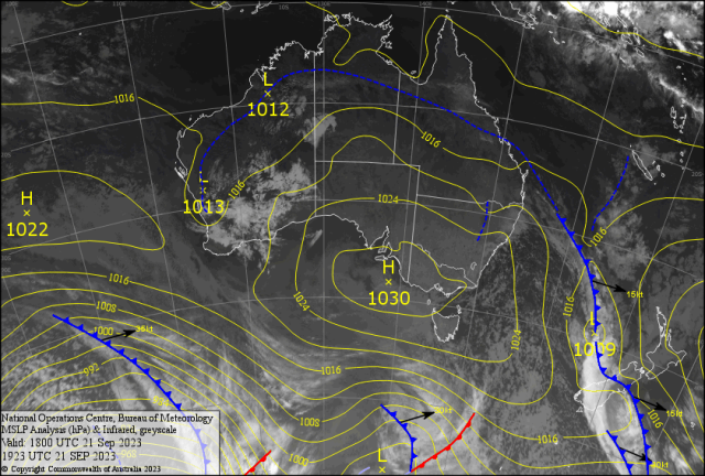
All happening on the northern edge of the southerly that hit NSW Wednesday.

After the record breaking September heatwave.

Penrith recorded 6 days( hottest 36.5C Monday) over 32C and Sydney equaling and breaking the September record of 35C.

Sydney Airport recorded 35.9C beating the previous record of 35.6C in 2000.

The Sydney Marathon started around 7am making for a finish in the late morning heat.

It was reported that 26 people ended up in hospital.

A southerly buster after starting in Victoria.

Hit Sydney 10pm Wednesday evening bringing relief to the heat.

Blew into Brisbane around 24hrs later on Thursday evening.

Reached Fraser Island around midnight then wafted into Heron Island 5.30am and sat on the edge of the fog in eastern Capricornia, which then burst through the Cap Coast during the afternoon.

All driven by a large 1030hPa HIGH over Victoria.

Amazing!

This cooler spell will help the FireFighters bring some control to the 70 fires about NSW and the numerous ones in QLD.

Reports of 58,000 hectares burnt in the Carnarvons.

Plus Expedition forest, Dawson Nat. Ft, Blackdown Tablelands and western Shoalwater reporting fires.

The SOI was -16 Friday and still falls, making one fear for the threat of more Fires to come. Mark, a CH farmer, said he has a 200 litre tank on his tractor all ready to go if a fire starts.

We all should take his lead.

So BE FIRE SMART- DON’T LET THE FIRE START.

Over 50 per cent of most fires are started by people.

We can help in buying a fire extinguisher and maybe put out any started fires immediately and prevent the 2019-20 season reoccurring.

Believe it or not!?

There was some rainfall in QLD around the Cassowary Coast and FNQ.

Best (mm) Cooktown 129, South Johnstone 48, Kuranda 30.

INTERNATIONAL

CHINA

After grappling with Severe Floods and Extreme Heatwaves.

Five people were killed, four severely injured plus 130 houses destroyed by two tornadoes that ripped through Jiangsu Province.

Separately at Yancheng south east of Suiqian north of Shanghai another five people were killed and four injured on Tuesday evening.

FRANCE

Storms in south eastern France recorded heavy rain and strong winds.

SPAIN

Streets turned into mud, cars were washed away like toys and bridges broke.

DANA – “Depresión Aislada en Niveles Altos” around Toledo.

USA

Water levels along the Mississippi River are falling for the second year in a row.

The drought conditions are forcing engineers to build a levee to stop salt water surging into drinking water in New Orleans.

FORECAST

The large high from Adelaide to Melbourne is causing stable cold mornings and cool days in the south east.

Yet driving cooler air from the “Mexicans” into southern Queensland.

This will make the pressure gradient strong along the QLD coast.

Causing strong winds with gusts over 50kph and two metre waves for the weekend into early next week.

It’s SOTW for the boaties!

There is a chance of a coastal shower mainly Sunday from Agnes to Shoalwater.

It may brush the Bruce early Monday.

This will make the Rocky temperatures Sat 27C, Sun/Mon 26ish Then rise slowly up to 31/32C Thursday.

A trough develops from near Monto to the Drummonds.

There is a chance of afternoon High Based Thundery Showers with “Dry Lightning” from Kroombit Tops (Happy Rock?) south to maybe Gympie and the Carnarvons to Taroom.

Then another version of the SETW should arrive.

AFL

Could the cold conditions Pies (Moore/Degoey/Pendlebury) in Melbourne stop the hot Giant Killers (Conigello/Kelly/Whitfield).

Nick Daicos sneaks in for the Brownlow, Lions will be roaring Saturday night.

Carrigan and Reno will be listening with Walsh bringing the Broncos home at Suncorp.

We can see Cleary (sunny weather) now as ours local boys Storm (Harry/Cam) fade in Sydney. Plus 33C Mohali as AUS/IND ODI with no Head and Kohli.