Last Saturday Rockites woke to thick fog with The Airport recording 100m visibility.
It happened again Sunday morning with that version clearing before 6am. The light winds and a trough over inland Queensland plus the weak pressure gradient over Capricornia, the NE sea breeze from the coast helped cause another fog starting after 2am with visibility down to 300m around 6am clearing after 7am.
In my time in Rocky I have never seen more than four fogs in a row.
Conditions looked good for the 5th.
Wednesday morning – it was touch and go – only a short lived fog cleared early.
Then Thursday morning Ian from Jardine Street noticed fog patches at the airport and Alan at Frenchville said it was thick.
So it is argueable we have witnessed a very rare six fogs in a row.
Could be an all time record!?
What a strange start to spring.
Even stranger the minimum Friday morning was 20.4C. Yes! Just like summer.
We have not recorded a minimum this warm since a one off 20.5C on the 5 July.
We have to go back a further three months to the 18th April for the next warm morning.
How bizaar! To add to all this a band of cloud from the north east Coral Sea moved onto the coast between Cardwell to Bundaberg.
This caused early morning showers with an isolated thundery for the Capricorn Coast.
A showers started in Rocky just after 1am Friday lasting a few minutes.
The radar was showing a possible storm off Curtis Island that persisted from 3am to just around 7am.
Plus something heavy around the mouth of the Fitzroy and Tannum. Here are some of the totals (mm) I could gather – Tannum Sands 23, Rapleys 22, Gladstone 18, Agnes 14, Byfield 12, Boyne Island 11, Iveragh11, Broadmeadows 11, Musgrove 8, Lamington 8, Brecknell 7, Penlington 6, Samuel Hill 6, Calliope 5, Briggs 3, Airport 3, Yeppoon 2.
In contrast wild wind gusts to 90-1001kph demolished house in Frenchs Forest and de-roofed a house in Peakhurst in Sydney.
In Melbourne AFL Demons and Magpies clash Thursday evening; after 4mm of rain on the MCG; set the scene for a blockbuster start to the finals.
The Magpies handled the damp surface early and kicked early goals with Bobby Hill in the vanguard.
Plus Moore/Murphy/Quaynor stopping everything in defence.
Then the Demons once they got their footing; came back with Oliver and Petracca winning the Max Gaurn clearances to just go down by seven points.
A real heart stopper in the end. Now the Broncos had a storm to content with on Friday night. If the storm arrives early then they may not have enough juice to carry through to the evening.
The SOI is rising! it was 12 last week now its -9.
Does this mean we may be border line for the El Nino?
INTERNATIONAL
GREECE
After the extreme record summer heat Storm “Daniel” hit Greece.
The port city of Volos recorded massive floods which triggered land slides, road washaways and sweeping dozens of cars off the roads.
Athens plus Bulgaria and Turkey were affected with 14 deaths across the region.
Louise Osbourne (Climate Reporter) is saying the extreme heat is helping to evaporate more water and develop more storms with torrential rainfall.
USA
Hurricane Jova (pronounced Ho-vah) is the first Cat five hurricane to develop about 550miles south west of the southern tip of Baja California this year.
It is packing sustained winds 252kph a real monster.
Its moving north west at 32kph and should not impact any Pacific Islands.
It should produce large waves which will impact the Californian and Mexican coast.
Hurricane Lee in the Atlantic is a Cat five and travelling in a NW direction well off the Florida coast.
Not since records were taken in the last century has there been a Cat five Hurricane in both oceans at the same time.
SPAIN
At least three people died near Toledo as heavy rain swept away cars and turned streets into rivers.
Madrid,Castilla-La Mancha, Catalonia and Valencia regions were affected plus the rail was closed..
HONK KONG
Over 158mm falls in one hour causing flash flooding in the city.
Breaking a 140 year record.
Streets turned into torrents and the Hong Kong Kowloon tunnel was inundated.
FORECAST
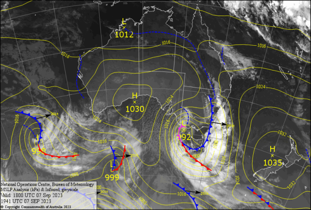
A deep LOW 992hPa centre (see map) is about to hit Melbourne.
Squally showers and storms hit Adelaide Thursday now its Melbournes turn.
Its termed a “Cold Outbreak” .
As cold winds from south of Tasmania blast into southern Victoria with gusts close to 100kph and storms with hail.
The cloud over the Central Queensland coast has tropical origin which has caused morning showers for the coast Friday.
As the trough inland approaches isolated storms develop from NSW into southern Queensland late Friday.
Will they reach CQ?
After humid NE winds an abrupt cooler southerly arrives Saturday with gusts over 20 knots (37kph).
Making it SOTW for the BOATIES.
Winds turn SE with gusts close to 25kt (45-50kph) and two metre plus seas.
This should drop the minimums into the low teens and maximums a pleasant 26/27C (feel 25C) for the early part of the week in the River City.
Just the odd coastal brief shower might reach the Bruce Highway Tuesday?
A high develops over southern Queensland Wednesday which should reach CQ Thursday.
More fogs are on the cards late week – maybe into the weekend.
GOTW for the BOATIES as the ocean should be pristine!?