Be fire smart, Don’t let the fire start
High temperatures could mean the start of an early fire season. Picture: Supplied.

Last Friday the 32.3C was the hottest day since a one off 31.2C on 26th June this year.

There were only a couple of rainfall reports(mm) Tannum Sands 1, Saddler’s Springs 1, Tanderra 0.2 and Samuel Hill 0.2. Not much!

Reports of fires at Mount Morgan with one motorist jumping out of his car with a fire extinguisher putting out a Razorback fire just before it took off.

Hats off to the man concerned! Then the following Saturday the maximum crashed by 7.8C to 24.5C.

With the real cold kicker on Sunday morning minimum of 6.2C.Och!

A 9.3C fall from the previous morning.

Amazing! Nobody got out of bed early.

The cold SSW air kept conditions rather cool for the following days with strong winds offshore making boating rather uncomfortable.

Yet it eased back mid week only to surge up again by Thursday with Rundle gusting to 22knots (41kph) early Friday.

Extreme temperature and weather swings develop around spring time.

Last August Rockhampton recorded 135mm for the month with 22 rain days.

This August only 2mm has been recorded in the past 30 days.

Making the countryside very dry heading into September.

Yes, looks like a bad Fire Season is on the cards.

I’m told most of the fires are caused by humans.

Most Wildfires in the US are caused by campers, back burns gone wrong, equipment malfunctions, cigarette butts and arson.

Very similar here in Australia.

Should we take ownership and suggest we all carry a fire extinguisher (like old mate last Friday) keep it turning and maybe help our beautiful country from burning.

The SOI after falling to -13 has now risen slowly to -10. Let’s hope it continues.

INTERNATIONAL

USA

Hurricane HILARY the first to hit the south Californian coast since 1939, caused mudslides in San Diego, floods in the Grand Canyon and Dodger stadium outside of Los Angles was like a castle with mote.

In contrast a woman died while hiking the Grand Canyon in excessive heat in July.

Maui Fires at least 114 deaths and 850 remain missing.

Cost estimates of nearly $6 Billion losses to businesses and homes.

Ironically the ancient town of Lahaina which was reduced to an ashen landscape means “cruel sun”.

Many families feeling no hope are moving out.

Daniel Swain a climate scientist from the University of California said “20 years from now a summer like this is going to feel like a mild summer”.

SPAIN

The 4th heatwave of the summer hit most of Spain and Portugal.

Maximums of 40C in a number of areas.

Around 12,000 residents are returning home after eight days of the Canary Islands Fires destroyed over 14,000 hectares.

GREECE

Eighteen people believed to be refugees were found dead in a Wild Fire that raged through the Dadia National Forest bordering Turkey.

Plus maybe eight more bodies?

Firefighters from Cyprus,Romania, Czech Republic,Croatia, Germany and Serbia battled the blaze.

TAIWAN

Tropical Storm SAOLA, developed east of the Philippines and on Thursday afternoon was about 460km east/south/east of Eluanbi Taiwan’s southern point.

It is projected to cause showers for the east Coast of Taiwan mid week.

Another depression near Guam may affect the region in coming days.

CARIBBEAN, FRANKLIN

could reach hurricane force by Saturday.

Winds are expected to be sustained 100kph with gusts over 200kph.

Seems to be travelling northward well off the US coast.

ITALY

A deep low near Monarco could develop storms with possible floods from Milan to Turin Monday.

FORECAST

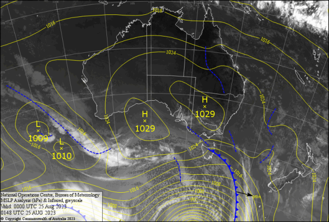
The twin like highs over south eastern Australia are causing cold mornings and fog for most of the southeastern quarter of Australia.

A front blasts through Tasmania (see map) could be causing the last snow for the season.

Along the Queensland coast the SETW caused gusts over 50kph and two metre seas from Fraser Island to Thursday Island.

Reports of an odd shower from Port Clinton to Stanage Bay Friday.

Some isolated squally showers along the exposed coast should continue for most of the early part of the week.

Afternoon temperatures under the “Trade Wind Inversion” should stay 27/28C with minimums 12/13 for the River City.

This is a tough call coming as Spring jumps in!

A high develops in the Tasman Sea which should weaken the pressure gradient along the coast mid week.

Light winds may for consecutive early mist or fog.

An Upper Cold Pool (UCP) develops over NSW causing storms with possible hail Tuesday.

A trough develops along the southern Queensland Coast.

Question is, will the upper dynamics allow the Jetstream to trigger high based storms in southern Queensland.

I’m scared to say this “Dry Lightning” is possible.

Mainly in the south but if the maximum reaches 30C plus for Capricornia and the upper dynamics is right late week then we may have a chance?