First 30 degrees since April
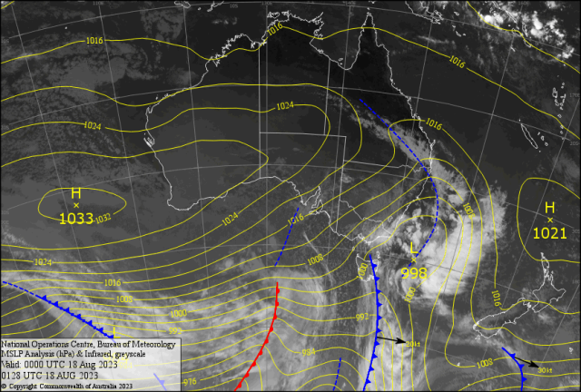
Cold south westerly winds with showers and possible sleet for Tasmania and eastern Victoria. Picture: Supplied.

Rockhampton and surrounds recorded its first consecutive 30C maximums since April this year.

No rainfall for the River City since the 3rd August has made the countryside rather dry.

Now the maximums are over 30C and the relatively stronger warmer north westerly winds Friday have caused authorities to call for a high fire danger.

There was a fire at Calliope Wednesday that closed the Bruce Highway.

A strong surface inversion with a lot of smoke particles in the air assisted in forming a decent fog for Rocky and surrounds Thursday morning.

The visibility got down to 100m at 6.30am at the Airport clearing quickly to a hazy day.

Early mist Friday morning with a report of 4000 -5000m between 12am to 2am.

Then a low cloud base about 1100ft covered most of the Fitzroy and covering Mt. Archer, followed by a rather warm sunny windy afternoon.

For the first time this (late) winter inshore winds started light WSW/WNW then swung around to moderate to fresh NNE afternoon sea breeze.

Gusts got up to 54kph from the NNE around 4pm near Great Keppel Island Thursday, Then 52kph from the NNW 7am Friday morning.

All signs that the winter is retreating and spring is in the air; Graham asked!

How come Rocky is 30C and places north of use were in the mid twenties?

A high moved over CQ making for light W to NW winds (land influence), yet to our north the onshore South East Trade Winds, allowed the cooler sea surface temperature to advert onto the coastal areas.

This transition from winter to spring can give a 20C plus range in minimum to maximum.

Last Tuesday the minimum was 8.1C and the Maximum was 30.6C and a 22.5C temp range instead of the normal 10-12C range for winter.

Best seven day rainfalls I could find for the week across Queensland were: Bingil Bay 20, Atherton 14, Tully 12 and Applethorpe 5.

While in Melbourne the average maximum has been around 15C and minimum 7.5C, this might be a bit cold for the Lions to beat the Magpies, as the maximum is forecast to be 12C Friday with a hint of sleet.

Being at Marvel there is a chance the Brownlow Medalist Lachie Neale could step up with “handlebars” Charlie Cameron and steel a win!? No Broncos!!

Can the Dolphins stop the running Brooks of the Tigers with Kodi and not to Kaufusi bring a win to Queensland after the Cowboys failed.

The Matildas did us proud after the cracking Sam Kerr goal, now we play for third place in the Women’s World Cup against Sweden/ Kickoff 18C in Brisbane around 5pm Saturday.

Go Sam!

The SOI has plateaued around -13, this equates to the lowest SOI since 2019.

We all remember what happened back then, will the El Nino in the Northern Hemisphere (that caused the heatwaves and fires Europe/China/India/USA) translate into the Southern Hemisphere?

More on this next week.

INTERNATIONAL

HAWAII

The Maui fires have claimed over 100 deaths and many missing.

As Hurricane DORA had an embryo in the Caribbean traveled more than 9000km across the eastern Pacific Basin.

A staggering report that it lived 45 days and just died in the western Pacific Basin.

Is this another record?

USA

No Hurricane has been recorded crossing California Coast.

Yet Hurricane HILARY may change this, HILARY was a Cat 3 with 120mph winds may hit southern California late Saturday.

While Heatdome temperatures continue in the central and north east US.

INDIA

A Tropical Low in the north west sector of the Bay of Bengal looks menacing.

It could impact Bangladesh and north east India over the weekend and cause floods.

JAPAN

Typhoon LAN made landfall in western Japan early Tuesday.

Reports of sustained winds of 150kph and possible rainfall totals of 350mm; in the Tokai region (home of Toyota Motor Company).

EUROPE After the heatwaves and record temperatures in July there has been a slight reprieve.

Yet another one seems to be developing over France Friday and reaching Spain over the weekend.

The Heat Dome could affect southern Germany, Netherlands and maybe south east England mid week.

FORECAST

The 998hPa Low centred off Gabo Island (see map) is associated with a front over Tasmania.

This is causing cold south westerly winds with showers and possible sleet for Tasmania and eastern Victoria and snow for the ALPS.

This complicated system has a trough going narrow through Barcaldine/Roma/Miles/Warwick early Friday with mainly a light shower and gusty winds.

There is a chance of a one off thundery shower as the trough travels east reaching Duaringa/Wowan/Moura/Gayndah late Friday.

This means warm to very warm temperatures for Central Queensland ahead of the trough then an abrupt colder drier south westerly to follow behind the trough.

Should reach Emerald by the afternoon and Capricornia during the evening, we may receive a short sharp shower overnight Friday on the Fitzroy.

BOATIES! SOTW! This will cause a rapid shift of wind from the NW and back anti-clockwise to the SSW with fresh to strong winds at times.

Chaotic seas will crest to two metre and possibly more offshore.

May be a trap for young players as it may look good on the beach, Check Rundle Island winds? Sunday morning minimums (wait for it) – 6/7C for the River City and 2/3C Bilo (Br! Br! Br!).

Maximums around 25C inland and 22C for the coast for the remainder of the period.

As the SETW returns with a coastal brief shower Monday/Tuesday reaching the Berserkers Tuesday.