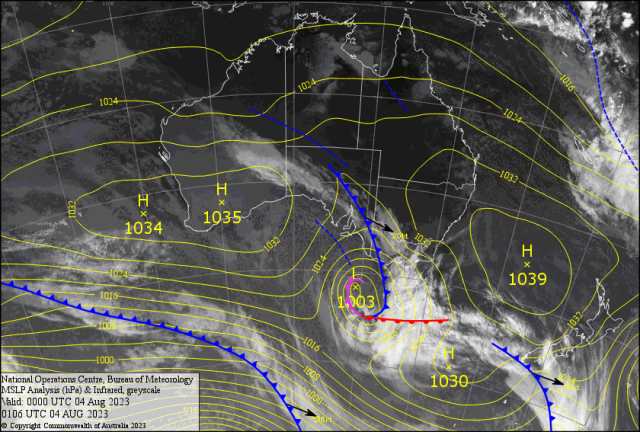
As the South East Trades Winds (SETW) surged up last Wednesday a very unstable air mass developed over the coast.
As the winds blew with gusts to 38kt (70kph). Small storms developed off Bustard Head early morning and popped up near Keppel Sands just before dawn.
The strong wind shear only allowed one or two small storms to cross Nankin around 6am (thanks Janelle) then pop up and down about the Berserkers during the morning causing light intense showers for Rocky.
Most falls are around 3-4mm from Parkhurst to the Range and Frenchville. Just enough to add to the green grass after the 72mm total for July.
Then the sun’s afternoon heating developed into one small storm which dumped 10mm in as many minutes ( maybe more??). The 2km wide rain shaft from Briggs Street to the Grammar caused a peel of thunder around 2pm; according to Alan.
Sadly most other places missed out. The wind made the ambient temperature of 24C drop the Apparent Temperature (AP) to feel like 20C.
Most sea operations were slowed with peaks over 3m with a spike of 4m offshore.
The Wallabies face a hard task in Dunedin with a 3C min and 8C max. No wonder it was named the “House of Pain.”
Matildas play Denmark in Sydney Monday 11C/18C. Will the coastal showers reach the west??. Makes the Melbourne weather of 7C to 14C range a mild heatwave!?. While CQ basks in 24C maximums.
No wonder the caravans and boaties are milling around CQ. After gusts to 178kph at Maatsuyker Island ( all time record) off Tasmania another blast should hit overnight Friday into Saturday.
INTERNATIONAL
ITALY – Farmer Andrea Ferrini in Forli, Northern Italty was hit by a rare frost in April, then torrential rain in June (killing 15 people) followed by a heatwave in July with 47C temperatures. “A severe hail storm was the final blow! How can I make a living??”
USA – In California over 82,000 acres were burnt from New York Mountains to the Mojave National Park. Burning and threatening groves of 150 year old Joshua trees.
CHINA -Over 30 inches ( 750mm) caused some of the worst flooding in 140 years. Early count of 26 deaths with over 800,000 people were evacuated around Beijing as the remnants of Typhoon ” Doksuri” caused destruction in eastern China
JAPAN – Typhoon “Khanun” swiped southern Japan with Okinawa recording two deaths (so far) and 62 hospitalized
FORECAST
The large strong HIGH in the Tasman has a peak centre of 1039hPa ( which is unusually high) driving the SETW along the whole Queensland coast.
Squally isolated showers (in exposed areas) continue from Brisbane to the tip.
The Berserkers may stop any decent shower reaching the Rocky Swap. This means boaties SOTW – Stay Off The Water.
There may be a short easing around Monday – if we are lucky. Then it boots up again as the Bight high redevelops in the Tasman.
And drops off again very quickly Thursday. Could be a fog patch or two around as the mornings dip below 10C. Winter returns with minimums 3/4C (feel zero) about the Capricorn/Central Highlands border. Yet brilliant sunny days to follow.