It’s getting cold in here

There was a light patchy drizzle most people received around 0.5mm early in the week, with Allan in Frenchville getting the best total at 1mm.

This was associated with coastal light showers brought on by the South East Trade Winds (SETW). Gusts of over 50kph at Great Keppel Island (GKI) kept the seas around the 2m mark.

The best total for the week was Sam Hill, with 19mm from Friday to Wednesday. Conditions have been a bit windy in the River City, with cool mornings and warm sunny days for most of Central Queensland. Thangool got down to 3.3C early Thursday and Mount Morgan close behind. All of a sudden the winds dropped to 5 knots in Keppel Bay Friday morning. How did that happen Byron asked? Here is the answer! Capricornia was on the southern edge of the SETW. Now a high has moved over Capricornia dropping the winds. The Trade Wind Inversion ( TWI) around 7000ft former wide spread stratocumulus cloud a little gloomy early; stopping the chance of fog forming. People froze in the south with wind gusts to 96kph in Port Phillip Bay, and Laverton a suburb of Melbourne, got down to 3C. Adelaide recorded it coldest minimum for the year at 2.9C. And Glen Innes in NSW recorded a super cold minus 10.8C on Thursday morning. Unbelievable! Perisher recorded a relatively warm minus 6.8C. And Applethorpe a modest minus 1C. While the Matildas were playing Ireland in Sydney Olympic Park the mercury sat on 7C all Friday evening. Yet in FNQ, Tully recorded 62mm and Low Isles 48mm as the SETW blew all week. The SOI has been sitting on +3, which is considered neutral. While Europe/Asia/Americia are in Heat Wave or El Nino conditions with fires and flash floods/ The Italians are calling it CHARON – the boatman who carries the souls of the departed to Hades.

FORECAST

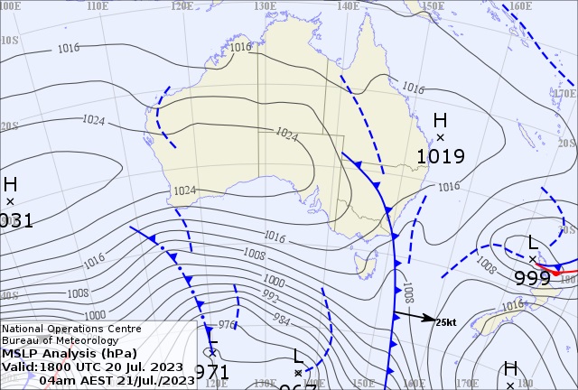
The weather map shows a front that blasted through Victoria and Tasmania affecting NSW. A high near Central Queensland moves east dropping the winds for most of southern Queensland. The upstream high near Alice Springs ridges east just south of the Tropic of Capricorn. What’s not evident on the map is an Upper Cold Pool (UCP) developing about 18,000ft over NSW. This moves over southern Queensland late Sunday forming storms in its wake. It look like developing thundery activity for southern eastern Queensland/Burnett ( Bris to Fraser Island) and force cloud into Central Queensland. This strange storm event may develop from Lady Elliott to Bustard Head/1770 late Monday. Then the Bunker Group of Islands (Heron) overnight reaching GKI and Shoalwater early Tuesday. Rocky should get light precipitation late Sunday into Monday and a light shower for the Berserkers Tuesday. Rainfall totals 20-30mm offshore for the event with maybe moderate (10-15mm) isolated fall near the coast with an odd convective fall somewhere in Capricornia. Monday and Tuesday look like the coldest days with 10C min and 20C maximum for Rocky. If cloud breaks Biloela could dive to 2C with the Highlands following suite! Sorry boaties! The winds are back again Monday and may stay for the week.

INTERNATIONAL

EUROPE

A massive heat dome has rewritten the record books across Europe. The heat wave has been dubbed “CHARON” by Italy. As fires in Greece, Sardinia and the Balkans. On the edge of the dome, severe storms killed at least six people from the ALPS to the Balkans (Croatia/ Slovenia/Bosnia), also causing lightning strikes that started multiple fires.

USA

Heat continues in southern US. With Phoenix shattering a 50 year record of 20 days over 110F (43.3C). Early Wednesday’s minimum of 97F (36.1C) was the hottest minimum on record. Reports of 12 confirmed deaths due to the “silent killer”.

Tornado EF3 in South Carolina damages Pfizer building.

State of emergency declared in In Kentucky floods.

NASA climate scientist Peter Kalmas said, “There is no stronger sign than the climate crisis is here?”

CHINA

Ancient Buddhist Cave murals and statues on the Silk Road, dating back to the 4th century, are in danger of being washed away.

ITALY

Sardinia the temperature reached 46.2C and Sicily 44.8C with Rome 42C – all time records.

FRANCE

New all time records, with Cannes 39.2C, Aups 38.6C, Renno 38.3C

INDIA

Monsoonal Flood waters in the Yamuna River rose 152 metres and lapped the Taj Mahal. Second time in 400 years.