Record fogs hit CQ

Monday recorded 31.2C for the River City. While Gladstone recorded a June record of 30.3C.

A good 6.5C above the long term average. The warmer than normal temperatures extended into the Central Highlands and Central West.

Emerald recorded 32C and Longreach 33C – nearly 10C above normal! Very unusual! Temperatures were rather warm with little rainfall. Only rainfall I could find was 0.6mm total forYeppoon and Samuel Hill.

Then I stumbled on to 0.8mm for St. Lawrence. Had unconfirmed reports of a possible record of fog fog days in a row.

This could account for the precipitation with heavy condensation droplets forming. Rocky and surrounds came in a close second with four fogs in a row from Friday to Monday. One of the old ‘Cockies” plus Indigenous folklore suggested rain should follow!

In the Northwest of the country a Northwest Cloud Band ( NWCB) developed early in the week and caused good rain from the Kimberley to the Alice. Some totals(mm) of interest – Gibb River 82, Siddins Creek 75, Kalgoorlie 34, Dampier Downs 58, Broome 30 in WA. Yulara 80, Curtin Springs 59, Suplejack 41, Finke 33, Hugh River 27, Bond Springs 23, Inverway 20, Alice Springs 18. While in Queensland best totals (mm) for the week were 10 Horn Island, 5 Coolmunda and 4 Roma.

INTERNATIONAL

USA – Heat Dome (large High pressure trapping heat) has stubbornly stuck over Texas to Mexico the last two weeks. This has been putting stress on the electricity grid causing power outages – forcing utilities to call for conservation. In 2021 researchers said human-caused warming made Heat Domes 150 times more likely. The Heat Index ( feel like) passed 45C in Dickson Texas. Leading Scientist Jennifer Francis said “…the Heat Dome is due to a kink in the jet stream.” Big Bend National Park recorded 119F (48.3C) – man and step-son died while hiking.

Tornado fatalities are the highest in a decade. There have been 23 deaths so far. Reports of 986 tornadoes so far this year compared to 863 to June 2022. So far 4677 Severe Weather Warnings – more than any other June since 2011.

The heat was associated with numerous Wildfires in Yuba -Sacramento California. Cal Fire has got most of the fires under control with an estimated total of 2000 acres burnt.

CHILE – Two people died with four missing as floods ravaged central -south Chile. Retrio in Maule Region recorded 156.6mm with roads cut in 40 places and 10,000 people isolated.

( NORTH ATLANTIC) BRITISH ISLES – A deep low 980hPa near Iceland over 100kph winds whipping up seas to 10m, moves slowly east. It reaches the northern tip of Scotland Sunday. This caused rain over most of the western parts of Ireland Wednesday and England Thursday. Made a late start for the Test Match in London. More patchy rain hits Ireland and Scotland Friday and light drizzle for Lords early Saturday.

FORECAST

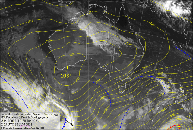
The Semi- Permanent High exchange across Australia is keeping most pastures dry. Zonal westerlies in the south are causing colder than normal conditions. With squally showers in the HAM ( Hobart/Adelaide/Melbourne) followed by snow on the Peaks.

The “Dry Season” north of the Tropic of Capricorn now has a NWCB operating. The 700/1000km wide cloud band enters western Queensland Saturday and sweeps across to the coast by early next week.

The drier SSW breeze late Thursday with a “mackerel sky” made conditions feel much cooler Friday although sunny for CQ. This may cut down the prospective rainfall totals from the cloud band. The fraying of the eastern edge of the cloud band suggests this ( see Sap Pic). Bilo may get down to a frosty 2C Saturday, Rocky 8C and Yeppoon 10C. The rain should start on the Highlands late Sunday evening. Then the cloudband has to make up its mind either to arrive early or late Monday in Capricornia. I’m going for the latter. Maybe a few spits earlier?

Minimums should rise to 15/16C with maximums 20/21C under sombre overcast light rain.

Turning to drizzle late Wednesday into early Thursday with sunny breaks. Rainfall totals for the period could be 10-15mm for the western Capricorn and double that for the coast. Then sunshine should return fully on Friday.