Early winter for CQ

Rockhampton recorded a winter like 11.4C minimum last Thursday morning, which was the coldest morning of the year (CMOY) so far. Yeppoon 14.9C and Gladstone 12.5C Thursday with Biloela 6.3C Friday early were also CMOY.

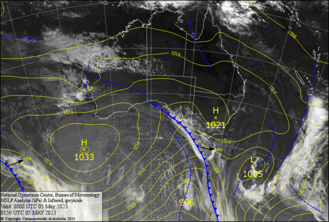
A low developed off the NSW coast last Sunday causing large six metre waves and heavy rain. Point Perpendicular recorded over 200mm in 24 hours.

This helped drive cold air from south of  Tasmanian into southern Queensland. Frost reached into the Darling Downs with Wellcamp recording  a frosty minus 0.4.  The dry cold air reached into western Queensland with temperatures falling by 5-6C with the first single figure minimums of the year.

Longreach got down to 8.6C, Birdsville 9.5C  and Mt. Isa 9.4C. The cold air from the south eventually pushed into CQ,dropping the minimums to the COTY.

Clermont recording  5.6C Friday. Emerald 9.6C and 6.0C Rolleston. Even Georgetown got 15.6C not seen in 7 months.These are all winter minimums. Far cry from the 19.9C minimum last Saturday with the 8.20pm shower (1-2mm) in George and Fitzroy Streets. As I drove along Fitzroy Street to Canning – low and behold – the road was dry. The shower of sorts did not make Davis Street till 11pm.

Then most of North Rocky close to midnight with 5mm. How Bizarre!! Some of the rainfall (mm) reports by early Sunday – Orana Park 27, Table Tops 25, Upper Van Dyke 20, Captain Creek 16, Thangool 14, Milton 12, Bauhinia 11,  Springsure 10, Woodleigh 10,  Raglan 8, Broadmeadow 8, Marlborough 7.6, Clermont 5, Rolleston 5, Middlemount 4, Mundic Gully 4, Gladstone 3.6, Calliope 3, Duaringa 3, Dululu 3, The Glen 2.8, Rocky AP 1.2. The wind drop made the ocean like a millpond with just a shore break Sunday. So the boaties revelled in the lesser seas.

FORECAST

Another front moves through VIC causing squally showers in Melbourne with a maximum of 13C Friday. I’m frightened to look at the Apparent Temperature!

Will it cause an upset in the AFL like the rain at Bathurst did to the West Tigers and Panthers NRL game last Saturday. How does the bottom team with no win after 9 games, beat the reigning premiers?

Tim Sheens, the past Super Coach pulled a weather game out of his bag of tricks. Brooks kicked 2 – 40/20 which lead to two tries. Plus the passing went to 2 hands. While Penrith passed three times for a poor completion rate and lost the ball. Amazing. Now another cold Antarctic Burst hits VIC/NSW with heavy rain for the south coast of NSW similar to last week. Rainfall should not be as heavy relatively; but the following cold air should blow into Queensland. Winds in KB should be SE Saturday  around 13-15 knots and a little lumpy on the water.

Chance of a brief drizzle shower for the intrepid BOATIE. The SE/E  breeze as the pressure gradient opens Sunday 7-10 knots. Inland cloud  with a spit should  threaten the coast. Minimums 14-15C and Maximums 28/29C inland plus 25-26C maxes for the coast over  the weekend. Then look out! The upstream ridge tightens the pressure gradient and punches colder SSW 20-25 knots winds into southern CQ Monday.

This will drive air from VIC northward. Overnight minimums will crash with Rocky close to 6/7C and Bilo near zero Tuesday. Maximums 22/23C for the River City then 21C for the coast – BR!BR!BR! Feel like 3-4 degrees cooler in the wind. Coastal waves  2-3 metres ( more!!) with squally showers should drift into the Fitzroy with a light shower Thursday.  The SETW is back with a vengeance and may stay for some time.Beware the IDES OF MAY!?