The winds blew for a good week.
Not since August 2022 had we had sustained winds of 25-30 knots gusts over 60kph for a week. After printing it in the paper and going on radio and saying SOTW (Stay off the Water), seas were over three metres with the odd roller over four metres in Keppel Bay.
That didn’t stop two youngsters trying to get to Great Keppel Island last weekend. Their tinny was rescued thanks to Yeppoon Coastguard off Sloping Island. The winds eased below 20 knots ( 37kph) for the first time in a week on Friday.
As the pressure gradient eases the abating trend should continue. Winds look to be less than 15 knots Saturday then Sunday under 10kt. Which means GOTW ( Get on the Water) Sunday with seas less than a metre.
The SETW made it drier inland. Showers developed offshore with some reaching the coast. A standout 21mm at Byfield. Other totals (mm) for the week – Samuel Hill 13, Pacific Height 2. The Monsoon for all intents and purposes has retreated to the Torres Strait. Yet some heavy rain on the Cassowary coast with South Johnstone recording 384mm early in the week. Other falls (mm) – Mt. Sophia 299, Lockhart River 136, Cairns AP 136, Hamilton Island 78, Nambour 44, Mackay 40, Miami 38, Redland 35, Logan City 26.
Sydney broke an 110 year record of 184 days in a row of maximum temperatures above 20C finishing on the 19th April. The previous record was a 180-day sequence that ran from 6 November 1913 to 4 May 1914.
October 2022 was the wettest October on record with 295mm 4 times the average. Sea surface temperatures were warmer than normal.
Darwin is experiencing its wettest Wet Season in 5 years 1678mm already has 1900mm. Very close to finishing soon.
INTERNATIONAL
ASIA – Record April temperatures from Thailand, Myanmar, Laos, Vietnam extend to China and Malaysia. Climatologist Max Herrera: “..endless record heat in SE Asia… records falling every day”. All time record maximum Theinzayet 43C (Myanmar). Bangkok recorded 42C with a feels-like temperature of 54C. In the Philippines 100 students were treated with heat stroke in Laguna. Teachers are calling for distant learning strategies and keeping the children at home.
USA – Severe Storms in Pennsylvania are causing trees to come down and kill a 12 year old and a two-year-old baby last Saturday. An EF2 Tornado, New York’s first for the season. Started 6.30pm and lasted 22 minutes, carved out a 16km path with a maximum speed of 185kph. Yosemite National Park was closed for three weeks after a record 15 feet of snow fell on Tuolumne Meadows. Fears are for rapid snow melt to cause flooding in the Mississippi River.
FORECAST
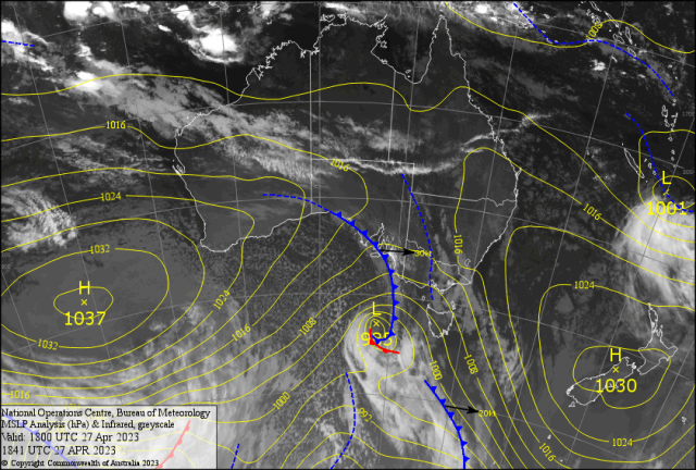
A 995hPa Southern Ocean Low about 700-800km south of Adelaide ( see map) . Has a front going through Robe/Adelaide/Ceduna Friday. This will cause squally showers and the odd storm in southern SA. Then TAS/VIC/NSW as it moves east. An Upper Cold Pool (UCP) could develop a severe storm or two in its wake.
This may form a version of an East Coast Low with a chance of triple figure falls for the NSW southern coast. A less severe northern portion should reach Charleville/Springsure late Saturday.
Then the coast south of Gladstone late Saturday. This may bring a light fall in the River City. The moist onshore NE breeze should cause a light shower from Yeppoon north early Saturday and maybe patchy into the afternoon. Light drizzle may break enough for the Swans/Bros AFL game?? A cooler drier SSW early Sunday ( may have a spit) tends light NE by the afternoon. A brief shower GKI may reach Pacific Heights overnight. Maximums should stay 25C for the coast as the Sea Surface Temperature drops below 25C for the first time this year. After a cloudy day Saturday with a shower mainly on the Berserkers, Rocky may reach 26.8C. Then once the cloud breaks Sunday 29/30C is on the cards. Will the ridge in the south summon up colder drier air Monday and Tuesday? If so then minimums will be 10C or less at Bilo and cool to cold along the Bruce. Sunny warm days follow with a feel like 29C for the rest of the week.
Tricky ridge formation may allow some early mist/fog mid week. The lighter winds should be good for boating early to mid week . Still check Rundle and use the rule” if it’s 10 knots or less then it good to go?” Watch the ridge in the south. It may surge a version of a SETW late Thursday into Friday. This could cause a big question mark over the following weekend. WTS!