CQ’s autumn swelter

After sweltering maximums  of 35C last Thursday week then down to a cool to mild 23C Sunday, we then yo-yoed up to  29C Monday with the humidity continuing, making people wonder will this ever end?

We had four days over 35C from March into April. This was the fourth try for the weather to turn into autumn. The normal ridge that arrives to bring the cooler conditions arrived only to drop away again the following day.

One elderly pensinior said she had never experienced an autumn like this.

“You get one cool day with a shower then very humid summery days follow.”

Last weekend storms around the region caused some good falls. Water Park Creek got to 2.6m then dropped off quickly. Best total Byfield with an incredible 109mm. Plus a friend reported 95mm in one hour at Green Hill south of Sarina. A summer rainfall, not autumn.

Other three-day totals (mm) of note  – Yeppoon 74, Raglan 67, Broadmeadows 67, Milton 67, Statue Bay 66, Marula 61, Dairy Creek 57, Gladstone AP 55, Benaraby 55,   Bajool 55, Boyne Island 50, Marlborough 46, Zilzie 45,  Tieri 45, Calliope 44, Alma Ck. Bore 44, Williamson 42, Pink Lagoon 41, Rocky AP 35, Mirian Vale 30, Parkhurst 30, Bingegang 30,  Frenchville 29, Alton Downs 28, Yamba 27, Melrose 25, Norman Gardens 25, Kunwarara 24, Riverslea 24, The Range 23, Callide Dam 19, Stanwell 14. Cyclone “Herman” lasted 3-4 days off the WA north west coast indicating the Monsoon is still operating. Although its coming to an end soon. In the west storms in the Gascoyne brought unseasonal triple figure falls as a cloud band crossed the continent.

INTERNATIONAL

USA – Snow depth has been the highest in years in Colorado. And snow-melt is having some levels up 23% higher in the catchments. Becky Mitchell the Director of Water Conservation for Colorado, said Lake Mead (which has been battling drought for a few decades) “is  seeing the first or second hydrology since 1964”.

Wednesday 3.30am an  EF2 Tornado killed at least 5 people in Bollinger County, Missouri. Estimated wind gust 130mph (230kph twice Marcia). Blizzard conditions closed roads and highways in the Dakotas.Casper, Wyoming broke a 41-year record with 26.7 inches of snow.

FORECAST

Last Wednesday Rocky recorded  a minimum of 17.4C. The coolest morning in five months.

Then it was back to a swelter with 20C on Thursday morning. Winds eased with fogs about Wednesday morning with visibility down to 500m at Yeppoon and 900m at Rocky AP.

More heat as a trough develops from Brisbane to Biloela Friday with storms which could be severe in the south.  Hot northerlies will slow the Brisbane to Gladstone Yacht Race. Boaties beware! If you did not get the 4RO word about the light winds Wednesday/Thursday then the moderate to fresh northerlies Friday/Saturday will be rather uncomfortable.

The  Brisbane to Gladstone Yacht Race was a record last year of 16hr 13 min. The race time this year will be doubled with fresh NNE at the start tending NNW plus storms about Fraser Island.

There’s light at the end of the tunnel!

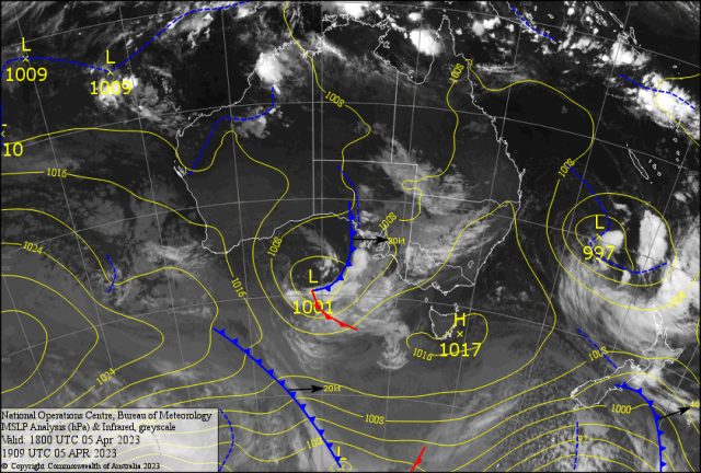
The low in Bass Strait moves into the Tasman Sea. Besides the Melbourne storm on Friday. This will cause cold southerlies for south eastern Australia from Tasmania into NSW then Queensland. . Melbourne looks like recording its coldest Easter Sunday on record with 13/14C and  light snow on the ALPS. Throw in the wind chill it would feel like 10C Br! Br! Br!. The cold air should have enough punch to reach CQ.  A cooler southwesterly should arrive Sunday then autumn will try again to arrive properly.  Monday looks like a  minimum of 16C and a max 31C.

Then cross fingers 14C early  Tuesday/Wednesday with Bilo about 10C.

Now will the cooler southerlies stay. Or will the winds turn northerly again and bring the heat back? A Tropical Low developing off Broome will have a say in this! Could it be “Ilsa”?