After a week of humid uncomfortable heat culminating in 35.3C Thursday.
A line of thundery showers from 1770 about 11km wide stretched along the Bruce Highway tapering to 6km wide to Gracemere at 12.30pm Thursday.
It reached South Rocky 12.40pm with 0.2mm lasting two minutes.
This was the prelude to the skies developing deep cumulus cloud development with dark cumulonimbus cloud topping out over 30,000 feet (thunderstorm cloud) causing lightning and thunderous rain during most of the evening.
Storms developed from near Alton Downs travelling eastwards to the coast. With reports of two storms across north central Capricornia.
A myriad of storm activity cracked across most of Capricornia with thunder from after 5.30pm around Rocky continued to 9pm and the coast near Midnight.
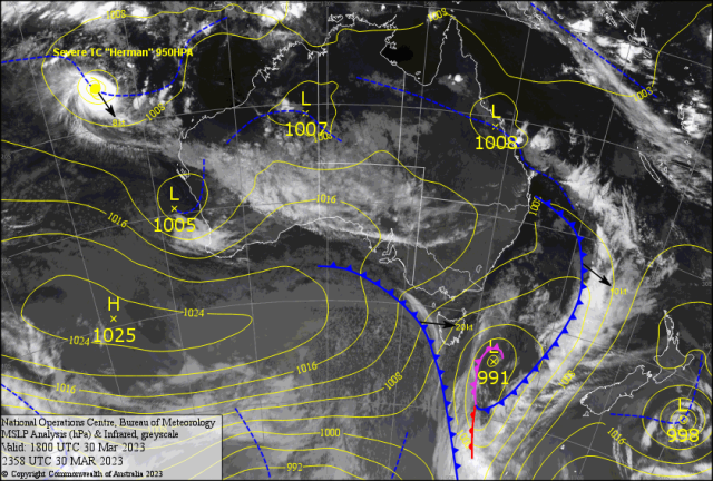
South Rocky missed the main activity while North Rocky and the coast copped the heavier falls. Some of the evening totals(mm)- Statue Bay 66, Rapleys 62, Zilzie 45, Dalma 40, Mt. Mongrel 36, Gladstone Radar 35, Glad AP 14, Boyne Is. 33, Alton Downs 28, Benaraby 30, Parkhurst 29 ( Brown & Hurley 37), Yaamba 27, Calliope 23, Norman Gardens 23, Marlborough 22, Briggs St. 22, Kunawarra 20, Hedlow 18, Miriam Vale 17, Samuel Hill 17, Sam Hill 16, Rocky AP 12.6, Musgrove St. 5, Bishop St. 4, Allenstown 3, Penlington 3, Lamington St. 3, Brentnell St. 3, Riverslea 3, The Gap 3, Westwood 3.6, Yeppoon 2( 18mm after 11pm). Still the weak Monsoon in the north is affecting the Central and Southern Queensland with moist northerlies. Best 7 day totals(mm) – Applethorpe 137, Horn Is. 110, Dalveen 107, Maroon Dam 99, Warwick 89, Texas 87, Oakington 79, Springbrook 67, Archerfield 59, Somerset Dam 55, Lockhart R. 54, Dalby 53, Beaudesert 48, Mundubbera 34, Redcliffe 32, Toowoomba 30, Walkamin 25, Cairns R. 21, Surat 20. Cyclone “Herman” a Cat 4 started Wednesday about 1800 WNW Broome.
About the same place where Freddy started in early Feb. This is associated with cloud from WA reaching the eastern part of Australia.
INTERNATIONAL
USA – The small town of Rolling Fork Mississippi was blown to pieces in just a few minutes by a huge Twister. A severe storm spawned an EF4 ( 170mph) tornado ( approximately 1km wide) with gusts over 300kph. Which blew trees down, flipped cars and turned houses into match sticks.
On 24 March reports of 21 deaths from the tornadic storm that tore a 59 mile path of devastation.
Now seven days later another such storm is brewing for Memphis to Chicago. Warning are out to seek solid shelter.
JAPAN – Meteorologist Hiroki Ito forecasts cherry blossom blooming dates for about a thousand sites in Japan. The practice of viewing blossoms – hanami- is centuries old and is worth Y616 bullion ( S7.1billion) to the economy 2023. The Japan Met Agency stopped forecasting the phenomena in 2007.
It was forced to apologise after an incorrect forecast missed by nine days. For March 2023 Ito forecast 15 March. Blooms were one day earlier.
Could not see the Berserkers till after 9am Thursday with reports of early morning fog patches at Tannum and along the Bruce. The small low near Bowen is fueling the unstable air across Central Queensland. So more unsettled conditions all the way up to Easter. The maximums should lower into the early 30s – even dip below Sunday to Monday with the threat of afternoon storms for the next week.
A trough associated with the low – if it shifts south – may trigger storms with a chance of 30-40mm from Ogmore to Marlborough to the coast late Saturday into Sunday.
And affect the River City! The moist northerlies tend south easterly for the coast causing overcast steady rain conditions from Sunday into Monday. More cloud conditions with showers early Tuesday. Still a late thundery risk. Then the cloud breaks Wednesday/Thursday allowing the winds to turn warmer (32-33C) humid NE. A trough develops to the Central Highlands. This will trigger thunderstorm activity that will edge into Capricornia. Timing is the issue!? You guessed it!? Easter Friday and Saturday is the timeline!? Sunday is on the cards! So campers and boaties beware!?