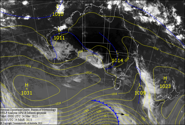
After the heat around the “Ides of March”, Central Queensland had the windiest week in a month.
A ridge with a strong pressure gradient delivered SETW with gusts that peaked at 33 knots or 63 kph in Keppel Bay on Tuesday.
Seas rose close to three metres with squally showers along the coast.
Rockhampton recorded gusts of 37 to 44 kph from Sunday to Thursday.
Gladstone gusted to 70kph, Yeppoon 61kph and Samuel Hill 46kph last Tuesday.
Even though we got coastal showers Thursday and drizzled inland to Alton Downs, the conditions felt very close to autumn for the first time this year.
An isolated storm caused 46mm at Byfield last Sunday, with 11mm at the Glen and 8mm at Samuel Hill.
Last Thursday, mostly light falls in the SETW, namely (mm) Emu Park 15, Yaamba 5, Samuel Hill 4, Melrose 3, Yeppoon 3, Marlborough 1, Rockhampton 0.2.
Heavy rain on the North Tropical Coast caused flash flooding affecting the clean-up of the monster floods in the southern Gulf.
The first major surge along the coast for autumn stimulated some of the leftover monsoons with some heavy falls.
Some 7-day totals (mm) Kuranda 212, Cairns 184, Tully 172, Cardwell 138, Cooktown 121, Southwell Stn 113, Lockhart 97, and Mackay 73.
In the south, Victoria had isolated severe storms that reached into NSW.
Visibility was down to 1500m at Tullamarine, and Mt. Buller recorded 32mm in 30 minutes on Thursday, while Wilsons Prom gusted to 83kph.
The Upper Trough system ran into NSW with Nobby Head 41mm, Coonabarabaran 35, Narrandera 22, and Burrinjuck 21.
The SOI has crashed from 15 to zero. Does this mean the La Nina is over?
Forecast
The SETW starts to ease as the pressures fall, the winds ease, and the temperature rises across CQ.
The best day for the weekend is Sunday.
A relatively weak low on the NSW/QLD border should stimulate storms over SEQ early weekend.
Temperatures gradually rise from 31C to 32C by Tuesday for the River City.
Then NE winds warm maximums into the mid-thirties inland, which may reach the Fitzroy late in the week.
A trough develops over eastern CQ Wednesday/Thursday.
This may stimulate some atmospheric lift and develop an odd storm that may reach the Bruce Highway late Thursday and Friday.
It’s getting misty further out. Maybe a fog in the making!
In the west, a low may develop where Freddy started in early February before it broke the World Record.