It’s dry, dry, dry

Temperatures set to climb to the mid thirties. Picture: Supplied.

After a brief stay on the Sunshine coast with the odd shower to green the area and the pristine beaches.

Arrived back in Rocky to find my nature strip extremely dry.

How soul destroying!

The winds during the past week have caused the evaporation rate to rise above normal levels.

Checking the rainfall for the last 72 days only 13 mm at Rockhampton Airport when we should have had over 90mm.

The dryness makes one hark back to October 2009 when we had bushfires in the Berserkers.

The month long fire continues in the Carnarvons and a fire between Expedition and Blackdown seems to be semi-permanent.

armer Mark last week saw a puff of smoke just near the main road of his property.

He raced with fire tender and grader; with the help of about 10 mates had the fire under control in 45 minutes.

The wind caused about 30 hectares to burn, he is convinced it was a cigarette butt.

Well done Mark in your prompt action.

SO – BE FIRE SMART – DONT LET THE FIRE START.

In this case prompt action saved the day.

Gladstone was lucky to get 11mm on Monday from a line of light showers stretching past Heron Island, in the onshore easterly that hit southern Curtis Island.

Sam Hill 14mm from last weekend to Monday.

Plus Pacific Heights 3.8mm.

Other totals (mm) in the state over the past week – Tully 49, Kuranda 28, Cardwell 27, Tewantin 20.

All from the onshore SETW.

In Victoria the floods in Gippsland covered the park benches and BBQ’s and entered houses in Sale a week ago.

Now the SOI has risen slightly to -10.5.

Still in El Nino territory.

INTERNATIONAL

PACIFIC

Super Typhoon “BOLAVEN” 210kph gust at Guam heads towards Alaska.

The Super Typhoon with gusts 346kph rapidly increased by 153kph in 24hrs over record warm waters.

Seems to be a trend in recent times.

Taiwan/Hong Kong

Typhoon KOINU struck east Taiwan last week with gusts 342kph breaking the all time record (records go back to 1897).

Which then caused floods in Hong Kong.

INDIA

At least 18 people were killed and 100 missing after heavy rain caused a Lhonak Lake; a Himalayan glacial lake; to burst its banks in Sikkim state.

USA

Rockies bracing for its first snow for the season.

The Mississippi River levels fell to all time lows for a second year as drought continued in the south.

The 400 mile stretch from Ohio River to Jackson is causing concerns for barge traffic during harvest season.

The low water has allowed saltwater to infiltrate the water treatment systems in New Orleans.

ARGENTINA

Half a dozen Wild Fires in Cordoba were brought under control as a cooler southerly arrived last Wednesday.

Hot dry northerly winds with the mercury 15C above average helped fan the fires.

Apparently a 27 year old man’s camp fire in the Punilla region got out of control.

Police are investigating.

FORECAST

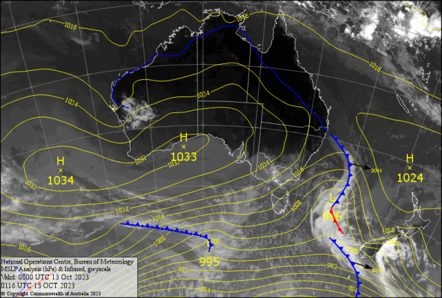
The large high pressure system over the Bight area is causing cold south westerlies with showers for Victoria and Tasmania.

The trough (stippled line) from Goondiwindi/Longreach to the Gulf has mainly light NE winds to the east of the trough.

This means light NW winds for the Capricorn Coast early followed by NE Sea Breezes with gusts close to 37kph during the afternoons for the weekend.

BOATIES enjoy the mornings!

Watch for early fogs and mist in the calm early morning conditions.

Yet inland temperatures climb to the mid thirties with 35C a chance in the River City Monday.

Isolated High Based Thundery Showers – with DRY LIGHTNING – could develop from the Kroombit Tops south to Agnes/Gympie/ Maroochydore late Sunday.

Maybe around Brisbane Monday.

Then the colder air south it shot into south east Queensland as the SETW ramps up Tuesday with gusts 50-55kph by the evening.

Chance of a morning coastal shower for the coast early Wednesday.

This should bring the temperatures back to 29/30C in western Capricornia and 25/27C for the coast.

And keep conditions on the drier side of the ledger.