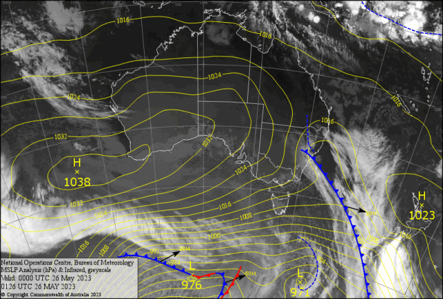
The large high over the southern half of Australia has been replaced at more than normal regular intervals for May.
Then moving up into Central Australia and southern Queensland. This is normally a June/July pattern.
For the month of May Rockhampton has had 5 days of below 10C and five days around 10C minimums. With 5.9C the coldest on the 10th May and the second coldest 6.9C on 22nd May. Yeppoon and Gladstone Airport recorded four days below 10C (on or near the coast).
Thangool/Biloela in the Callide Valley inland recorded 19 days with minimums below 10C, two days below zero and six frosts. Closest morning was 9 May with minus 0.6C. The mean minimums are all 2/3 degrees below the long term average going into winter. All due to repeated southerly air bursts from cold dry air past Tasmania into CQ. Friday morning fogs were prevalent in northern and western Capricornia.
With Rocky missing out with a layer of thin cloud about 6000ft stopping the surface cooling to the dew point. Melbourne is having its coldest May in 42 years. Which is indicative of NSW and southern Queensland with eight frosts already at Applethorpe in southern Queensland. Clermont on the Central Highlands has had 17 days with minimums below 10C and five frosts.
Longreach 14 days, Mackay Airport had seven days and West Townsville six days all below 10C.
Making most Queenslanders shiver before what is normally a June phenomena around Rocky Show Day. The early frosts have caused havoc with crops in the southern and western inland Queensland. Also WA early cold has only allowed 50 per cent of normal rainfall affecting planting. Plus causing most sheep and cattle to be grain fed. The early position of the major highs will affect eastern Australia going into winter. Plus if we look towards Spring could bring on an Early Fire Season ( EFS) if temperatures rise into the 30s quickly with lack of timely rainfall. Yet the good rainfall during the “Ides of May” may get Capricornia over the line if there is some follow up? The Cassowary Coast has had 83mm Bingil Bay, 37mm at South Johnstone and 26mm Tully.
While FNQ had isolated falls of 22mm Kuranda, 21mm Cairns Racecourse and 13mm Lockhart River. In the south less than one millimetre as the dry cold air engulfs southern Queensland.
INTERNATIONAL
USA – Meteorologists are watching a low developing off Charleston as the USA approaches Hurricane Season. Hurricane Expert Meteorologist Dan Kottlowski said: “If the system stays offshore then it’s a good chance of evolving into a tropical depression” Or – most likely scenario – it may spiral inland quickly with no tropical development .
ITALY – On 23 May flooding with landslides brought by storms with strong winds devastating the Emilia-Romagna region. Reports of six deaths in Forli-Cesena Province with several people still missing. Over 600 people have been rescued as river levels are still rising. Thankfully the rain has stopped.
FORECAST
A repeat of the previous weeks of a large high over western Australia with a trough along the Queensland coast. Plus cold snow showers for the Alps. Made for almost glass out for the CQ coast Friday. Once a low develops in the Tasman early Saturday. A shot of cold southerly air should hit CQ early Saturday ( mucking up the Boaties early) then dropping out rapidly late Saturday.
If the trajectory of the following ridge stays then Sunday morning could beat the coldest morning so far this year. Ouch!
Boaties beware of the early morning southerlies offshore. Then single figure minimums climb slowly to 10C by Thursday the start of the technical winter. Yet the days will be brilliantly sunny with a maximum of 24/25C for the week. Once the winds turn easterly the cloud returns and double figure mins are back.
The southern Australians with 15-17C maximums (feel like 10-12C) would be envious of this weather. If the south western flank of the high is in place over Adelaide on Wednesday. Then the extra couple of degrees over 17C during the day may give the Maroons the warm edge in the tackling department.
Particularly if the CQ brigade of Munster, Grant and Hunt are acclimatized with the Cherry on top combining to put pay to the Blues. Otherwise it could be Cleary a Payne!?