Get the latest news to your email inbox FREE!

REGISTER

Get the latest news to your email inbox FREE!

REGISTER
HomeCommunity NewsCQ autumn weather

CQ autumn weather

BIZARRE AUTUMN CONTINUES

Rockhampton recorded a hot 36.6C Thursday. Followed by a minimum of 13C Friday morning – a 23.6C fall. How Bizarre! The normal April Minimum to Maximum temperature differential is around 10C. Yeppoon and Gladstone recorded a maximum of 35C Thursday.

The very warm to hot north westerlies made for good boating weather for most of the week. Then to wake Thursday morning with a Rocky fog down to 900 metres at 6am blotting out the Berserkers with low pressures – amazing.

Then a cooler southerly hit the Keppels around 10pm Thursday. Gusts got to 21 knots (41kph) with the rapid change. Before the change the morning freshening north westerly tended north easterly during the afternoon gusting close to 20 knots (37kph). Rolling up the seas to 1.5 metres from a north easterly direction. Then at 10pm the southerly hit; turning the seas around to the south east. Rather complicated for anchoring at night off the islands. In fact I read a book on all the boat accidents for the Queensland coast prior to 2000. Nearly 80 per cent occured with the north west suddenly turning southerly mainly at night.

A large number of the accidents were very similar. Boats anchoring for a northwesterly at night were washed up on rocks in a sudden southerly. Even more Bizaar Cyclone “ILSA” a Cat 5 with reported gusts 289kph hit the Pilbara Coast off WA; close to Pardoo at 2am (WST) Friday. It’s April and a cyclone similar to Tropical Cyclone “YASI” (a summer phenomena) is impacting the Australian coast. The Monsoon this year has spawned some extreme events. Tropical Cyclone Ellie formed in Bonaparte Gulf off Darwin late December 2022 and dumped over 900mm in 24hrs at Fitzroy Crossing in the Kimberley early January 2023. Flooded the Kimberley for weeks. Then Super Cyclone “FREDDY” started off WA coast 6th February and after 36 days travelled the length of the the Indian Ocean crossing the African Coast twice and causing over 300 deaths. Called the longest lived cyclone in history. Then in mid March; close to 700-800mm was dumped from Century Mine to Burketown causing an inland sea which is still receding now. Enter Severe Tropical Cyclone “ILSA”!! Expecting some massive damage from winds and floods as the low travels eastwards via Telfer. The Sub- Tropical Jet Stream looks like grabbing it and steering it via Central Australia into eastern Australia. Arriving on the the east coast late Sunday into Monday. Interesting to see the different effects from Cairns to Sydney. Yes! Its moving that quick. While Melbourne had the coldest Easter Sunday in 80 years with 15.5C. Rockhampton had a hot 34.7C easter Saturday. Another Bizaar contrast.

INTERNATIONAL

USA – Fort Lauderdale recorded 25 inches (around 600mm) last Wednesday. A state of Emergency was called for Broward County. Heavy rain and intense lightning caused flash flooding that stopped cars ( remained on roads) and closed Lauderdale Airport. March and April are notorious for tornados. Records show many single occurrences in years gone bye of 30-40 deaths in 1977, 1998, 2008 and 2011’s Super Tornado. On the 28th April 2011 one EF5, 11 EF4 and 22 EF3 were confirmed. Reports of 252 people dying in Alabama alone and billions of dollars damage. Some people are still recovering from the trauma today.

CHINA – On Monday a Severe Sandstorm cloaked Beijing and north east China. An orange glow gave an eerie feeling as people with respiratory problems suffered. Particles exceeded 1.321 micrograms per cubic metre. This 45 times the WMO guidelines standard for poor air quality.

FORECAST

The low offshore associated with the cooler change Friday moves into the Tasman Sea and weakens. A Tropical Low develops north of New Caledonia. What are the remnants of “ILSA” going to deliver for CQ and the east coast? The cooler SE winds tend NE by Sunday. Cloud from ILSA reaches the Central Highlands late Sunday – yes it was that quick. Behind it a very strong high races into Central Australia. This combination of events may form a weak trough over Capricornia. A warm 31/32C sunny day Sunday for Rocky. Followed by the a cooler fresh SETW by Monday afternoon. Coastal light showers early Tuesday may reach the Bruce Highway. If the Tropical Low develops further in New Caledonia ( may cause some drama in Noumea) then the winds will increase late Tuesday into Wednesday for the Cap Coast. Maximums around 29/30C for the River City. Will this be the real autumn at last!?

Digital Edition
Subscribe

Get an all ACCESS PASS to the News and your Digital Edition with an online subscription
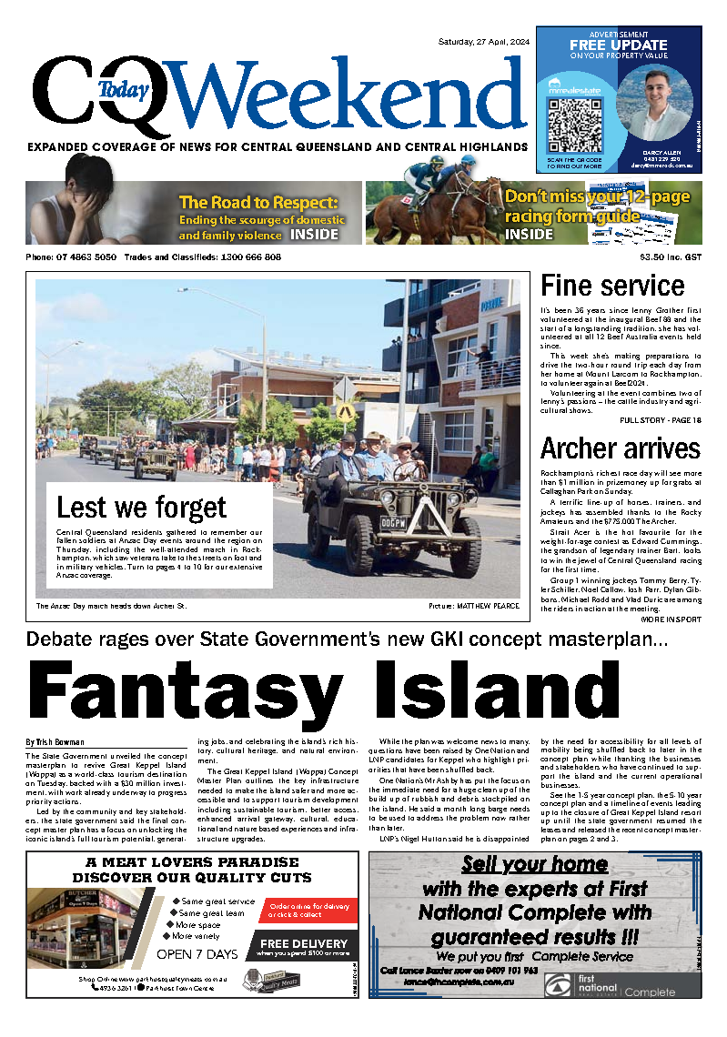
Northern Corridor in the spotlight

The future growth of Livingstone Shire’s Northern Corridor has come into focus at a recent Livingstone Shire Council meeting, with councillors backing key planning...
More News

Conway opens the Great American Songbook at Headricks

Headricks Lane will become the coolest jazz club in town on Saturday, 21 February when Angelo Conway sings Hits from the Great American Songbook. Developed...

Rising inflation hits

The primary cause of this week's interest rate rise is the massive blowout in government spending. Over the past two years, the Federal Government's...

More disaster funds for local clean-up and road repairs

Banana Shire and Gladstone councils can now access disaster funds for response and recovery activities including debris clean-up and road repairs. Ongoing flooding from the...

Safer streets with more police on the beat

This last week, another 79 new police officers joined the ranks of the Queensland Police. This cohort (the first for 2026) represents an important...

Condolence, then censorship

Parliament was recalled in January to deliver a national condolence motion for the innocent victims of the Bondi attack and to debate hate speech...

Astra Star can shine brightly at Doomben

Rockhampton trainer Kris Hansen will saddle up the locally owned Astra Star in Saturday's $75,000 BM70 Handicap (1350m) at Doomben, and perhaps surprisingly, punters...

Five races on offer at Pioneer Park

Central Queensland racing heads to Emerald's Pioneer Park on Saturday for a five-race TAB program. It is the Tropical Race Day at the Emerald Jockey...

Glencore, Rio abandon merger talks for third time

Rio Tinto has walked away from takeover talks with Glencore, ending months of negotiations over a ​tie-up that would have reshaped the global mining...

Community Events Billboard

Weekly Events Archer Park Rail Museum The Archer Park Rail Museum in Denison Street, Rockhampton is open Monday to Thursday 10am-3pm and Sunday 9am-1pm. Bring the family...

Teen brains hate early mornings – why should schools take note

If teenagers had their way, school would never start before 10am. And it turns out, neuroscience says they might be onto something. As The King’s School...